- Sections :
- Crime & Public Safety
- Restaurants & Food
- Sports
- More
MONTGOMERY COUNTY, TX -- July 8th 5:30am update: Hurricane Beryl has officially made landfall near Matagorda as a Category 1 storm.
This morning we are expecting the eyewall to move along the western side of Montgomery County.
Conditions will rapidly deteriorate this morning from 8am onward. Please don't get out on the roadways.
Forecast call from sustained winds of 50-65mph though the county with gust in excess of 75+mph west of I-45.
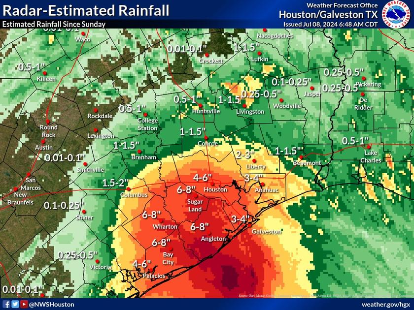
We're still not expecting rainfall in excess of 10 inches.
Forecasters are still confident in the forecast track and are telling us this will be the most significant wind event since Hurricane Ike.
Please don't take the current conditions outside as an indicator to what will happen today. Conditions will get a lot worse and not improve until this evening. Getting out on the roads today will potentially cause you to not be safe later in the Morning and day when Beryl gets closer to us.
The County EOC is fully activated and staffed.
With power outages expected please do not approach or drive around downed power lines. Treat all downed lines as live wires.
Stay safe and weather aware!