- Sections :
- Crime & Public Safety
- Restaurants & Food
- Sports
- More
CONROE, TX -- The heavy rains of late April and early May, which combined caused devastating low-lying flooding along the banks of the West Fork of the San Jacinto River below the dam, caused millions of dollars in damage to homes, personal property, commercial properties, and government facilities. Many people questioned the release of water from the Lake Conroe Dam, but the San Jacinto River Authority has a set of procedures they must follow in order for water releases to take place, and the unfortunate events that caused the flooding overwhelmed both the SJRA and the Coastal Water Authority, which governs Lake Houston. While Lake Conroe was 4 ft. above its normal level, Lake Houston was 6 ft.
The 140 billion gallons of water in Lake Conroe is a resource of The State of Texas, but a certain portion of the lake is permitted; about 100, 000 acre feet (or roughly 1/4 of the lake), with the City of Houston having a 2/3rd portion, while the SJRA has 1/3rd cut. Most of the drinkable water from Montgomery County comes from underground sources, with the rest coming from our lake.
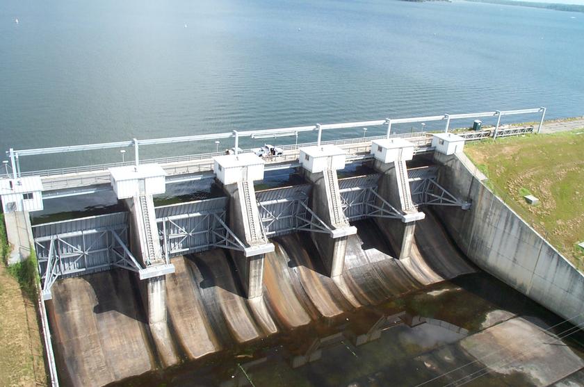
Lake Conroe is permitted as a constant level lake, maintained at a conservation pool of 201 ft. above mean sea level, or full pool, and is mainly used as water supply reservoir for the City of Houston. Anytime the lake is above 201, the SJRA is authorized to release water. If the lake is below 201, then it infringes on either SJRA or the CWA’s water allotment. The City of Houston, when there is a need, is able to call for water, like during droughts, to lower the lake below full pool, but the SJRA is not permitted to lower the lake below 201 by their own accord.
“We were releasing 12,500 cubic feet per second (cfs) on April 29th,” said Heather Ramsey, Director of Communications for the San Jacinto River Authority, speaking in reference to the heavy rain event of April 28th. “Then we started to gradually lower the amount of water released on and after April 29th.”
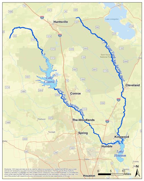
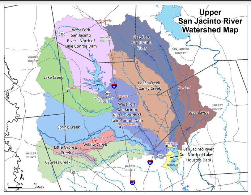
The West Fork watersheds includes the West Fork of the San Jacinto, both north and south of the Lake Conroe Dam, as well as the Lake Creek, Spring Creek, Willow Creek, Little Cypress Creek, and Cypress Creek Watersheds, all bodies that channel water to West Fork of the San Jacinto River converging just east of Interstate 69 and Lake Houston. Each storm is a dynamic event and with the storm on the morning of May 2nd, releases started going up, but couldn’t keep up. SJRA officials were aware of 3-5 inches of rain falling in the area, with isolated totals falling between 7-9 inches. But the northern counties received up to 17 inches of rain.
“We operate the dam so that the peak releases are never more than the peak inflows into the lake,” said Ramsey, telling MCN about the storm water and runoff that flowed into Lake Conroe from the northern counties. “At the peak on May 2nd, the inflows into the lake were up to 150,000 cfs, with the combined releases from all the gates were 71,000 cfs.”
It was essentially what the SJRA is calling a ‘rain bomb,’ that happened to land north of the Lake Conroe watershed on May 2nd. Had the event happened south of the lake or along the East Fork of the river, the outcome could have been very different as the river could have taken on more stormwater and perhaps causing much less of a flooding hazard.
“The dam passed through about half of the storm water inflows that otherwise would have been in the river,” said Ramsey. “We operate Lake Conroe on the same gate operations protocols each storm to protect the integrity of the dam.”
The East Fork of the San Jacinto River has no control structures like the Conroe Dam. Their watersheds include the East Fork of the San Jacinto River, Peachy and Caney Creek, and the Luce Bayou; all drain into Lake Houston from the north, along with its own watershed immediately surrounding it.
Lake Houston is 70 years old, and its spillway and water release gates are old and antiquated, and they are nowhere near the size of Lake Conroe’s gate which are 40 ft x 30ft. In fact, one gate was non-functioning during the event. The CWA has been wanting to install new water release gates since Hurricane Harvey in 2017, and although money has been allocated for planning and construction, it could be a number of years until the project is executed and completed, with construction slated to add eleven new gates to the eastern embankment of the spillway. The addition of those future gates will be a game changer, and can perhaps change strategies to coordinate releases between the dams to reduce flooding threats to a minimum, when events are projected in one or both watersheds of influence.
In addition, dredging projects for Lake Houston and the San Jacinto River have been added to the project to reduce the amount of sediment build-up on Lake Houston, and to make the waters path along the river banks more defined in order to better control floodwaters.
CWA protocols are in place for lowering Lake Houston for forecasts greater than four inches in a predicted storm event. For May 28th - May 1st, the forecast was only 1 to 4 inches, with over 4 inches further north. A 24 hour notice is usually given when lowering the lake by 12 inches within 72 hours of the anticipated arrival of the storm. CWA has noted that even if the second gate had been functional, the water would have still gone over the spillway.
“We were not releasing water prior to the May 2nd event,” said Erin Jones, the Public Information Officer for Houston Public Works, due to the weather forecast. “But the CWA did open their gates when the forecast worsened, once the storm event had started and had dropped more than 4 inches, and the water had overtopped the spillway.”
Jones went on to say that the City of Houston has not called for a seasonal lowering of Lake Conroe by six inches this past spring due to the city recently coming out of a two-year drought. The COH has lowered Lake Houston by 12 inches following the Active Storm Management Protocol for rain events this year. Houston will continue to monitor short and long-range forecasts for future storm management decisions and seasonal lowering.
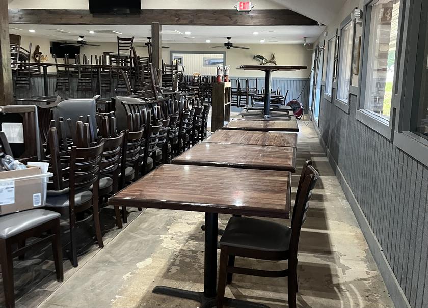
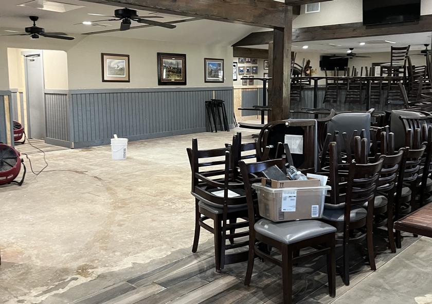
Vernon’s Kuntry Katfish, the coveted Montgomery County restaurant that flooded on May 2nd, is continuing its recovery. As of press time, the beadboard is back up, the painters are painting, and the new rug will be installed soon. Thankfully, the fryers, refrigerators, and other electronics that the restaurant needs to operate have been spared the wrath of the floodwaters.
“The restaurant is scheduled to be opened on Saturday, May 25th,” said Mary Bowers. “I owe everything to Blaze Benson and his company for getting everything back up and running.”
Ms. Mary also reported the 40th Anniversary Celebration that was scheduled for this month, oddly around the time of the reopening, will be postponed a while to give the restaurant a little bit of time to recover from their harrowing ordeal. It is quite evident that some sort of flood mitigation of the Vernon’s campus should be undertaken to prevent a third occurrence of flooding. The Bowers Family, employees, and the restaurant itself, cannot be put through the ringer every time a 500 hundred year flood comes by every seven years. Unfortunately, it is an undertaking that cannot be taken solely on the shoulders of the restaurant. It all boils down to us as a community, ‘do you want great food, or do you want a condemned restaurant.’
Ruben can be reached at: ruben@montgomerycountynews.net