- Sections :
- Crime & Public Safety
- Restaurants & Food
- Sports
- More

MONTGOMERY COUNTY, TX -- July 7th 10:00am: Tropical storm Beryl is moving northwesterward toward Texas. It is expected to remain on this northwest path through tonight, after which it will turn more to the north.
The system is expected to strengthen to a Category 1 Hurricane before making landfall near Matagorda Bay early on Monday
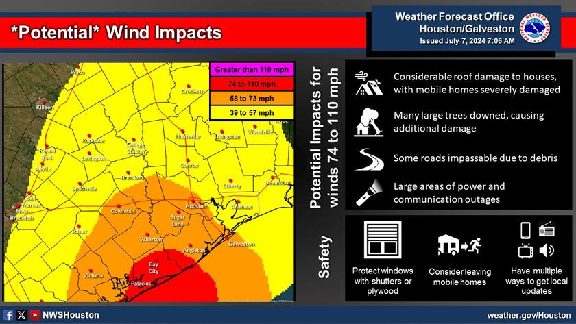
Beryl will continue to intensify up until landfall early Monday, and people should be preparing for the possiblity of a Category 2 hurricane landfall.
A Hurricane Warning has been issued between Baffin Bay and San Luis Pass, TX and for Jackson, Matagorda and coastal Brazoria counties. A Hurricane Watch is in effect for Galveston Island. A Tropical Storm Warning has been issued from San Luis Pass to High Island, TX and for all remaining counties in Southeast Texas.
Most likely impacts for Southeast Texas:
Strong rip currents and coastal inundation from storm surge.
Heavy rainfall and tropical storm to Hurricane force winds.
Long period swells and elevated tides developing.
July 7th 8:00am Update: A shift in the forecast track overnight for Tropical Strom Beryl soon to be Hurricane Beryl. The track shift is closer to Montgomery County now upon landfall Beryl is expected to move north east over Monday in our area.
The center of circulation is expected to be just west of Magnolia as Beryl passes by Montgomery County. This will put us on the "dirty" side of the storm and much closer to the center of circulation where the strongest winds are located.
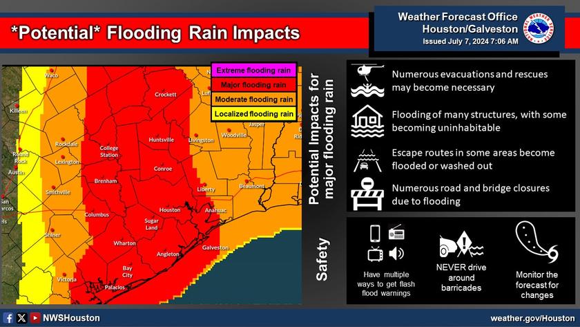
What to expect: Heavy rains starting today and ending late Monday night. 5-10 inches are still forecasted with areas West of 45 seeing higher amounts. The entire county is under a Flood Watch thru Tuesday.
Winds: We can start to see gusty winds later today with sustained wind speeds expected to be less than 60mph. With stronger gusts closer to the center, depending on where track goes. Expect stronger winds if you are west of I-45.
Today is your last day to make preparations and gather supplies. Ensure you have enough water and food for all members of your household to include pets. Fuel up your cars and make sure you have all your prescriptions. Keep in mind that power outages are possible when purchasing food supplies.
The county's Emergency Operations Center is currently activated at Level 3, and will transition to Level 1 (Maximum Readiness) this evening and will remain activated until the threat has diminishes.
Judge Keough has signed a disaster declaration this morning in advance of Hurricane Beryl's Landfall. This has activated the county's emergency operations plan and ensured all local resources and assets are available to ensure we are able to protect life and property as much as needed. This is in addition to the disaster declaration already signed by Lt. Gov. Dan Patrick.